Mount Singer Trail
Take a hike in the heart of the Green Mountains Nature Reserve
The trails of Mount Singer, in Mansonville, cover more than 78 km² within the Green Mountains Nature Reserve. Corridor Appalachien manages the Mount Singer trail network, whose summit rises to 810 m.
Surrounded by natural habitats that shelter hundreds of plant and animal species, 19.5 km of trails are open to both casual walkers and seasoned hikers.
Trails
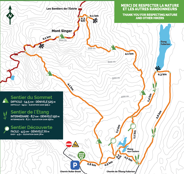
Discovery Trail
easy – 4.5 km – 70 m elevation gain
Summit Trail
difficult – 14.5 km – 525 m elevation gain
Pond Trail
intermediate – 8.7 km – 150 m elevation gain
GET YOUR PASS
By purchasing your access pass, you not only contribute to improving and maintaining the trail network, but you also support our mission to conserve natural environments as rich and magnificent as this one.
A vast trail network
The trails are part of a network of more than 125 km, accessible to both casual walkers and seasoned hikers. The other trails of the Green Mountains Nature Reserve are managed by Les Sentiers de l’Estrie and the Parc d’environnement naturel de Sutton (PENS).
Get ready for your hike
For your safety, please note that there are no public facilities at the entrance or along the Mount Singer trails.
Hike safely
- Start early to ensure you return before dark.
- If hiking in a group, follow the pace of the slowest member and do a headcount at every intersection.
- Bring a map and consult it often.
- Bring appropriate clothing and a change of clothes.
- Carry enough water and food.
- Never hike alone.
USEFUL NUMBERS
Corridor Appalachien – Green Mountains Nature Reserve: 450-297-1145
Les Sentiers de l’Estrie: 819-864-6314
Potton Tourist Information Office: 450-292-3313, ext. 336
Sutton Tourist Information Office: 450-538-8455
*IN CASE OF EMERGENCY, CALL 911 OR 4141


How to get there
The Singer sector of the Green Mountains Nature Reserve is located in the Township of Potton, near the village of Mansonville.
From Highway 10, take Exit 106, then head south on Route 245. This road ends in the village of South Bolton, at the intersection with Route 243. Turn left onto Route 243 and continue toward the village of Mansonville.
Before reaching the village centre, turn right onto West Hill Road. Continue for 6.4 km to the intersection with Ruiter Brook Road and turn right. Follow this road for 4.5 km. The trail entrance will be on your right.

